Joint press release from Louisiana’s Sea Grant and Louisiana State University Center for Computation & Technology
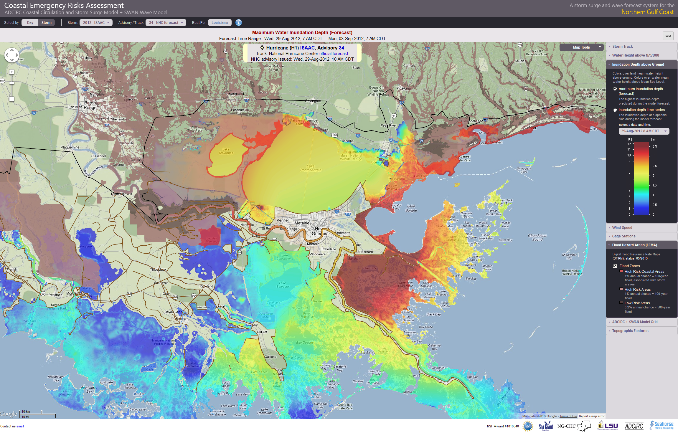
Baton Rouge, June 5, 2013 – The 2013 Atlantic Hurricane Season began June 1, and it's expected to be an exceptionally busy year. There are tools, however, that can help mitigate a hurricane’s impact. Drawing on the resources of Louisiana State University’s Center for Computation & Technology, scientists at the LSU School of the Coast & Environment have developed the Coastal Emergency Risks Assessment interactive website system (CERA) to visualize several parameters from the ADCIRC Coastal Circulation and Storm Surge Model during an active hurricane. These parameters include storm surge, wind speed, water inundation above ground and other.
The CERA interactive website system, established with support from Louisiana’s Sea Grant and the Coastal Hazards Center of Excellence at the University of North Carolina at Chapel Hill, focuses on two areas – the Gulf of Mexico (http://cera.cct.lsu.edu) and the Atlantic Coast (http://nc-cera.renci.org). The system presents five-day forecasts and delivers the model results in near real-time every six hours.
“This data can save lives,” said Robert Twilley, Louisiana Sea Grant executive director and one of the principal investigators with the CERA project. “It provides emergency responders with information on potential hot spots of coastal inundation and suggests where they may need to conduct search and rescue missions. Planners can look at it to determine where they need to stage relief operations. It also can be used in damage assessments.”
The CERA interactive website system is used by the National Hurricane Center, Weather Forecast Centers at the National Oceanic and Atmospheric Administration (NOAA), the United States Coast Guard and the Governor’s Office of Homeland Security and Emergency Preparedness in Louisiana.
“During a hurricane, Louisiana emergency managers meet every morning at the Governor’s Office, where they discuss the latest and most accurate model results shown on the CERA website,” said Carola Kaiser, IT consultant at LSU’s Center for Computation & Technology. “LSU CCT’s specialists insure that all the servers and the network operate smoothly so that results from the model can be delivered quickly, which is the key.”
Background information:
The model used by the CERA project, the ADCIRC Coastal Circulation and Storm Surge Model, is impressive because of its speed and detail. When Hurricane Katrina made landfall in 2005, computer models used about 300,000 nodes and took four hours to run a storm surge simulation. During Hurricane Isaac, 1.1 million nodes were used on three different storm tracks, and the simulations were completed in two hours using a suite of high-performance computers.
A node is a unique location on the map where the computer makes physics calculations to determine how water levels will change during a storm. The more nodes used means more detail in forecasting water levels across the state’s complex coast. Louisiana’s deltaic coast includes an extensive levee system, navigation canals, ridges, highways and natural landscapes of wetlands and barrier islands. As such, it is important to utilize the greatest possible number of nodes to capture the intricate nature of how people live in this setting.
The ADCIRC Coastal Circulation and Storm Surge Model is a multi-university effort. Partners include Louisiana Sea Grant, LSU, the Louisiana Optical Network Initiative (LONI), the UNC Institute of Marine Sciences, the UNC Renaissance Computing Institute, Seahorse Coastal Consulting and the ADCIRC Coastal Circulation and Storm Surge Model Group. Additionally, significant funding for the project came from NSF EPSCoR Northern Gulf Coastal Hazards Collaboratory, U.S. Department of Homeland Security Coastal Hazards Center of Excellence, and NOAA’s Integrated Ocean Observing System program.
About Louisiana Sea Grant
Louisiana Sea Grant, based at Louisiana State University, is part of the National Sea Grant Program, a network made up of 33 programs located in each of the coastal and Great Lakes states and Puerto Rico. Sea Grant Programs work individually and in partnership to address major marine and coastal challenges.
Since its establishment in 1968, Louisiana Sea Grant College Program has worked to promote stewardship of the state’s coastal resources through a combination of research, education and outreach programs critical to the cultural, economic and environmental health of Louisiana’s coastal zone. In 2013, the Program was rated highly successful after an evaluation conducted by the National Sea Grant Performance Review Panel.
For more information, please visit http://www.laseagrant.org
About LSU Center for Computation & Technology
The LSU Center for Computation & Technology is an interdisciplinary, innovative research center that advances the University’s Flagship Agenda and promotes economic development for Louisiana. It uses advanced cyber infrastructure, high-speed networks, high-performance computing, data storage
and analysis, as well as hardware and software development to enable research in many different fields. By uniting researchers from diverse disciplines, ideas and expertise are disseminated across LSU departments to foster knowledge and invention.
For more information, please visit https://www.cct.lsu.edu
Contact information:
Tatiana V. Johnson, Communications Manager
Louisiana State University Center for Computation & Technology
Office: 225-578-6088
Mobile: 318-332-2863
tjohnson@cct.lsu.edu
Roy Kron, Director of Outreach & Communications
Louisiana Sea Grant
Office: 225-578-6564
rkron@lsu.edu
